
Drzewiecki Design - Baku X v1.2[FSX/FSX:SE/P3D/P3Dv2/P3Dv3/P3Dv4]


Baku X is the first commercial scenery of Azerbaijan, featuring a highly detailed representation of UBBB Heydar Aliyev airport as well as lite models of all other Azeri airports, Baku city with hundrieds of landmarks and the whole-country photoreal ground. This product is compatible with FSX and Prepar3D.
The Republic of Azerbaijan is a country in the Transcaucasian region, situated at the crossroads of Southwest Asia and Southeastern Europe. It is bounded by the Caspian Sea to the east, Russia to the north, Georgia to the northwest, Armenia to the west and Iran to the south. The exclave of Nakhchivan is bounded by Armenia to the north and east, Iran to the south and west, while having a short border with Turkey in the north west. The Azerbaijan Democratic Republic proclaimed its independence in 1918 and became the first Muslim-majority democratic and secular republic.
Baku is the capital and largest city of Azerbaijan, as well as the largest city on the Caspian Sea and of the Caucasus region. Baku is located 28 metres (92 ft) below sea level, which makes it the lowest lying national capital in the world and also the largest city in the world located below sea level. It is located on the southern shore of the Absheron Peninsula, alongside the Bay of Baku. At the beginning of 2009, Baku's urban population was estimated at just over two million people. Officially, about 25 percent of all inhabitants of the country live in Baku's metropolitan area.
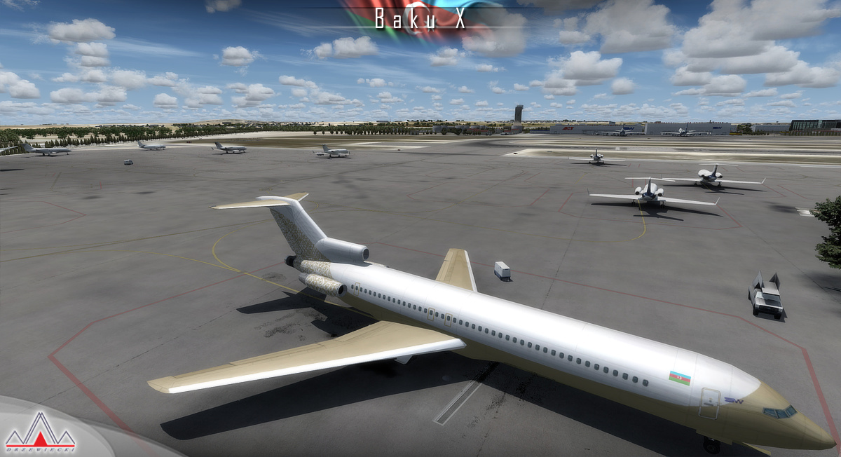
Heydar Aliyev International Airport (IATA: GYD, ICAO: UBBB) (former Bina International Airport) is the main international airport in Azerbaijan located 20 km (12 mi) northeast of the capital Baku. The airport is the home of Azerbaijan Airlines, the national flag carrier. It is the busiest airport in Azerbaijan and of the Caucasus.
Scenery features:
- Extremely detailed model of UBBB Heydar Aliyev International Airport in Baku
- UBBB with 3D people, high quality static aircraft, custom animations, rain effects
- SODE animated jetways and advanced interior modeling (Terminal 1, tower, Silkway hangar)
- Baku city with hundrieds of custom-made landmarks, night textures, detailed autogen
- 8m/pix optional photoreal coverage (with mesh) for the whole country of Azerbaijan (~80.000km²) plus ~8000km² of Iran, ~7000km² of Armenia, ~6000km² of Georgia and ~11.000km² of Russia (we followed mountain ranges and other georgaphical features rather than political borders)
- Lite models of Lenkoran, Ganja, Nakhchivan, Qabala, Zaqatala and Zabrat
- Enhanced AFDs with library objects for Dollyar AFB, Nasosnaya AFB, Stepanakert, Kyurdamir AFB, Balakari, Akstafa, Kala AFB, Yevlakh and Naftalan
- Custom-made UBBB airport charts included
Download Size: 2GB

![[FSX/P3D] Aerosoft - Airbus A320/A321 w/SP3 (v1.30a)](https://blogger.googleusercontent.com/img/b/R29vZ2xl/AVvXsEi8NM7Ll7YLvbuYKzVw7VLIvKsh5mEJ-zbtNPyqywq9iNn7jiuHiOMgZz5JwE9zZEQEG2eawQQkGbUkr9g6N_Gsnot6IRBjbcYD_IixLkhUS_hVFKOLvS1SGZV5jiY9rpY3Q8ClF0TqFxbv/s72-c/airbus-a320-a321-10.jpg)
![[FSX/P3D] ORBX FTX Global v1.30](https://blogger.googleusercontent.com/img/b/R29vZ2xl/AVvXsEgiX0dNO2cLo31jnsXNnfxVm_ZgiOaPJPlJ8j7HNHJd8euX3UwX6r5zFRFoJWLPuE1j9glic_1G0b9EH3ELTR_OGjr1O_PhU3J94xRjte1u862ILckWoMLV7SW68iIlPDgx1q6-nV9bRc4B/s72-c/6YY31l_70.jpg)
![[FSX/P3D] REX 4 Texture Direct with Soft Clouds](https://blogger.googleusercontent.com/img/b/R29vZ2xl/AVvXsEilWM6Ca4e6yVdbO5CXLhg2t3BjxdleEy8fs1OlHGs39S4QOj_aulqkbW-lbSOm_E2YjiTImaegyQ9mw9x64e4S3L6_OuVRnHy2Ah8eHej1ZH4SpQxxtAZYUE-rAuVZ_ZCg93MbDMJvk-xN/s72-c/td03.jpg)
![[FSX | P3Dv2 | P3Dv3 | FSX Steam] Aerosoft A318/319/320/321](https://blogger.googleusercontent.com/img/b/R29vZ2xl/AVvXsEhi0yrkfTf2ciL4LisqQGW6c5wUpRnH5fpob6LzJXzQu39c0SdJoexP9Cu9IyaDJ3R9lWZGNHn6yOARgORr2Km9Bc6CbMNONNns7OCtOStsHOwrt2y8yf7TStU1AkJGPq91tGwx0Mh9MyEU/s72-c/1786cbf812192635f2068be9f1637c54-fsx-2015-02-26-16-35-08-90.png)
![[FSX/P3Dv2/P3Dv3] Carenado Dornier DO-228 v1.1](https://blogger.googleusercontent.com/img/b/R29vZ2xl/AVvXsEgcLZjx7UI2ZTfOhg2XZYLb02aryRVQ4EGMTNQHpt-TyVbXuaHaksYpohrQiOiCW7UzhWQvVZji5DzAdUfkLulfGZc2Iol7t5qhQKWzG_Pl534O7b1JWu8u2vrbBZlUfY2Mc_hyphenhyphenHLU673ym/s72-c/download.jpg)
![[FS2004/FSX/P3D] Aerosoft - Professional Flight Planner X v1.28](https://blogger.googleusercontent.com/img/b/R29vZ2xl/AVvXsEif9ZaDwOppjrb6VMBfe4kjcW2XWWtP0Gi4a1aBEu7ndwzuPOuLDfA30CEgHqyAEeu9o61NJ1belzOKhvspR01KPvCAuS6AEexnQd2uDyaqYbtnqpF41VZsTCTxtTlkHluf-xkzI5QCI1Yk/s72-c/pfpx.jpg)
![[P3Dv4/v5] PMDG 737 NGXu + 600/700, BBJ, Cargo Expansion + Crack](https://blogger.googleusercontent.com/img/b/R29vZ2xl/AVvXsEi-f8A8CIZY9JMyIXqo0v_IW3ZHE5_wrSh2_bLHMP08nXOyn4lyBRufKSpEZtps_LWupZc-SkmEEbMtC3I6pUukt3mouKS-vBLFdYa8U8mz9Zrlaffdy7pnGtpX1HvfHutg9fZ9HPhkgHtz/s72-w640-c-h360/737-NGXu-Cargo-Expansion-2-1.png)
![[P3D/FSX] FS Real Time v1.97](https://blogger.googleusercontent.com/img/b/R29vZ2xl/AVvXsEitYSNGvuR5xek7AHMd4cJL8zW74eAbCtmRFLb_mDtt7ijoGm4GOT-CMUI_KGP0FLw0DZLP9IaxrSwaj0kOllQSJiDeXNazMureu5mHiWSzEVb2WrbCv_eAsUi03qOwUsbwF4-kOwDO5Tm8/s72-c/FSRealTimeMontage2.gif)
![[P3D] Prepar3D v4 Professional Plus 4.0.23.21468](https://blogger.googleusercontent.com/img/b/R29vZ2xl/AVvXsEidkILen61RgJcoxqpwtXxXx0-176RRgingBdB5IjCjCHSnKTz6r3Rzn2u67FIZx0naQsRub3eqlhOsxOCRK5EXb1HDd5k2FqPrUfNAhEJOc6gYHAY-vYpDq4X68P1gOdO8IvwaT-dIjF9P/s72-c/maxresdefault.jpg)
![[FSX/P3D] MJC8 Q400 Cockpit Sound Immersion HD](https://blogger.googleusercontent.com/img/b/R29vZ2xl/AVvXsEjVwxekDiMklv-a4lbaVUZY3aA84rWxza98InFz8PtZ_VGsZfL_kdC7Aef1Un2IQyWUMdaVk_wamK4xrZoADeYSMx1Rmhk9fOcE0HxC-r_KjuP8ISBK4PfzpTkIaekuRt-1qcTRQLJBsniU/s72-c/173736_MJC8-Q400-Cockpit-Sound-Immersion-Screenshot.jpg)
Comentar